HALIFAX, NS / ACCESSWIRE / December 14, 2020 / Namibia Critical Metals Inc. ("Namibia Critical Metals" or the "Company" or "NMI") (TSXV:NMI) is pleased to provide an update on its gold exploration programs on the Grootfontein and Erongo projects which cover 1,950 km2 in the Central Namibian Gold Belt. Both projects underwent regional exploration with the objective of identifying orogenic gold deposits. Progress to date is reported as follows:
- Three gold targets defined at Grootfontein (80 km northeast of B2 Gold's Otjikoto Mine) based on low detection limit gold anomalies, up to 6 kilometers in strike length coincident with favourable structural lineaments
- The delineation of a major gold anomaly covering 25 km2 at the Highlands Target underlines the potential for gold discoveries within the massive Grootfontein Mafic Complex.
- Grootfontein target areas covered by thick calcrete. Follow-up with high resolution UAV magnetic and ground induced polarization ("IP") surveys to define drill targets
- Soil sampling completed over Erongo (20 km from Osino Resource's Twin Hills discovery) has identified three priority target areas defined by strong arsenic anomalies coincident with favourable structural lineaments.
Namibia Critical Metals holds four Exclusive Prospecting Licences ("EPLs") comprising 2,150 km2 within the Central Namibian Gold Belt. The EPLs are situated within the Central Namibian Gold Belt which hosts a number of significant orogenic gold deposits including the Navachab Gold Mine (4.41 Moz)1, the Otjikoto Gold Mine (1.83 Moz)2 and more recently the discovery of the Twin Hills deposit. Gold mineralization throughout the belt is associated with northeast striking fault zones and second and third order structures related to these faults which have been identified on the Company's EPLs.
Don Burton, President of Namibia Critical Metals stated "With the delineation of gold anomalies at Grootfontein, the potential of the Namibian Central Gold Belt now extends for 400 kilometers in length. Investment in the belt has been driven by the historic gold discovery at Navachab, the success of B2 Gold's operation at Otjikoto and the on-going drilling success at Osino's Twin Hills discovery. We are well positioned in key areas of the belt and we are especially excited about the Highlands Target which covers 25km2 and is clearly open to the east."
1 Navachab resource source Anglogold Ashanti press release February 10, 2014; 2Otjikoto gold resource source B2 Gold website December 2020 Corporate presentation (indicated resources = 1,460,000 ounces gold and inferred resources = 370,000 ounces gold)
Work by the Company completed to date includes detailed structural interpretations and mapping over the entire Grootfontein and Erongo project areas, and regional soil sampling programs over designated target areas. Over 16,000 soil samples have been collected and analysed for pathfinder elements using handheld XRF analyzers. Low detection gold analyses have been completed on 5,685 of these samples from Grootfontein. Gold analyses are pending from Erongo.
Gold Exploration Targets at Grootfontein
The Grootfontein project area comprises two EPLs covering 1,643 km2 located 80 kilometers northeast of B2 Gold's Otjikoto Gold Mine and 20 kilometers northeast of Osino Resources' Otjikoto East Project.
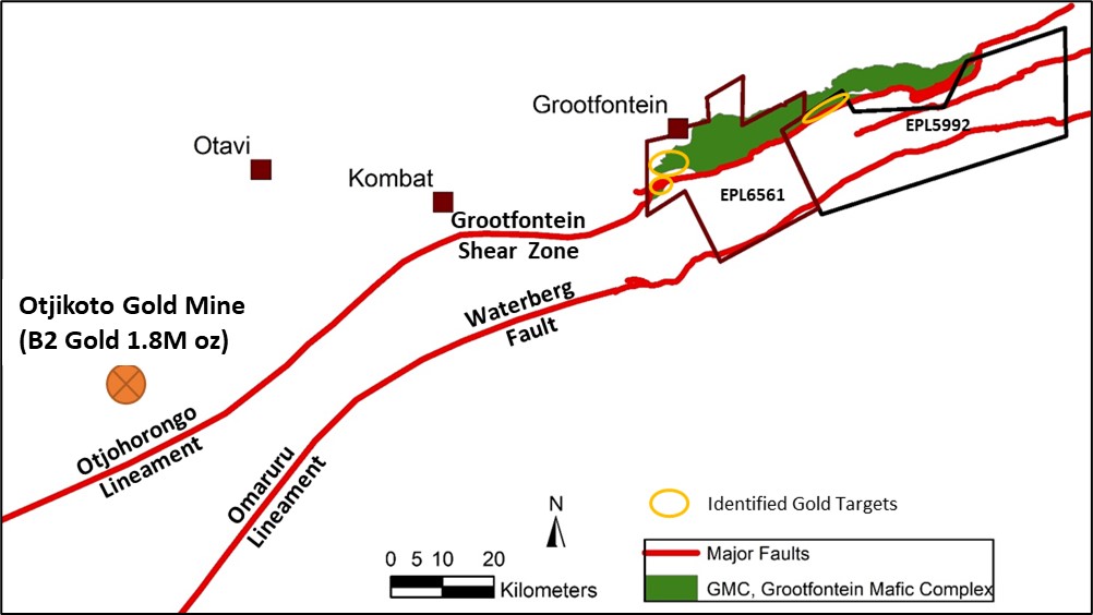
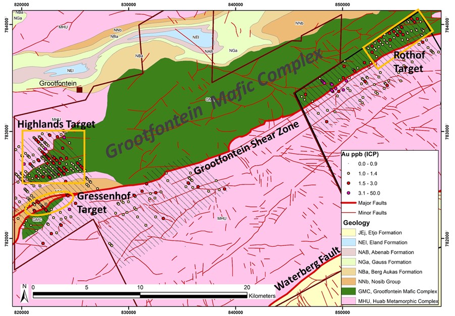
The geology of the property is dominated by the Grootfontein Mafic Complex ("GMC"). Grootfontein lies at the northeastern extremity of the Central Namibian Gold Belt where the Grootfontein Shear Zone ("GSZ") transects the GMC and is bounded to the south by the Waterberg Fault (Figure 1). Gold anomalies identified to date at Grootfontein occur within the mafic rocks of the GMC itself and in basement and Damaran Supergroup rocks in proximity to the Grootfontein Shear Zone (Figure 2). The project area has extensive alluvial and calcrete cover up to 40 meters in thickness.

Figure 1: Location of the Grootfontein EPLs and relationship to major structures within the Central Namibian Gold Belt.
A structural interpretation of the entire project area was undertaken by Earthmaps Consulting using airborne magnetic and radiometric geophysical data together with 1:250,000 scale geological maps. The study provided a detailed structural analysis of the area delineating the Grootfontein Shear Zone and the Waterberg Fault, and associated second and third order structures considered favourable for gold mineralization, with a focus on the potential of a 50 kilometer long segment of the GSZ. Given the extensive calcrete cover, regional-scale soil sampling was undertaken to identify potentially mineralized zones associated with the GSZ.

Figure 2: Key gold exploration targets at the Grootfontein Project (low detection limit gold ICP analyses of soils).
Sampling lines 400 m apart. Structural and lithological interpretations by Earthmaps Consulting
Results have outlined three large, low-grade gold anomalies of gold related to the GSZ as shown in Figure 2:
- The Highlands Target covers an area of 25 km2 situated 2.5 km north of the Grootfontein Shear Zone. Gold anomalies are associated with second order structures over strike lengths up to 6 kilometers within the Grootfontein Mafic Complex (GMC) and following the contact zone of the GMC and the Huab basement. Orogenic gold deposits in sheared mafic intrusive rocks are well documented and this represents the first such target in the Central Namibian Gold Belt
- The Gressenhof Target is coincident with the Grootfontein Shear Zone over a strike length of 3 kilometers and is underlain by metasediments of the Damaran Supergroup
- The Rothof Target is a well-defined, linear corridor following second order structures over a strike length of 6 kilometers, immediately north of the Grootfontein Shear Zone within the GMC.
Follow-up of all three targets will be undertaken using high-resolution magnetics with UAV (drone) and induced polarization geophysical surveys to delineate drill targets. Regional soil sampling will continue to fill in the 20 kilometer gap between the Gressenhof and Rothof targets along the Grootfontein Thrust Zone and explore the second and third structures within the basement rocks to the south.
Gold Exploration Targets at Erongo
The Erongo Project area comprises 320 km2 and is largely underlain by metasediments of the Damaran Supergroup dominated by a turbiditic sequence of metapelites of the Kuiseb Formation and syntectonic granites of the Damaran Orogen. The Kuiseb Formation hosts the Twin Hills gold project of Osino Resources just 20 km south of the Erongo Project.
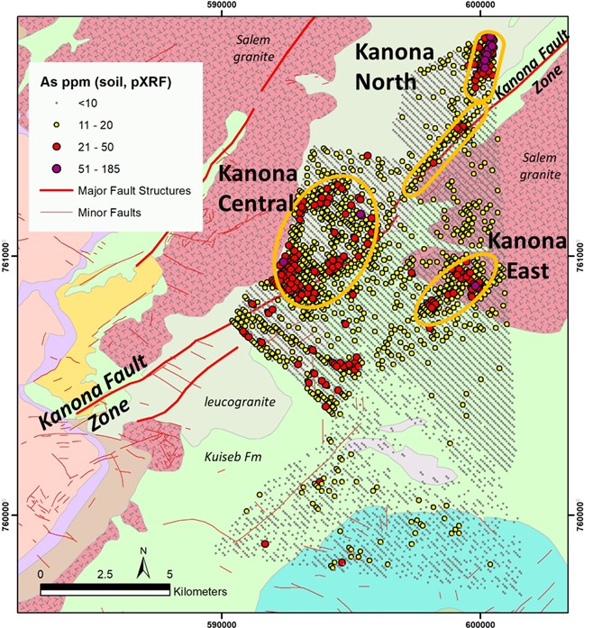
The structural interpretation of the entire project area by Earthmaps Consulting delineated the Omaruru Fault Zone and the Kanona Fault Zone, both of which are considered prospective for structurally controlled orogenic gold mineralization. The project area has extensive alluvial or calcrete cover and regional soil sampling was undertaken as the initial exploration tool to identify areas of potential interest. Over 8,000 samples were collected and analyzed by handheld XRF for base metals and gold pathfinder elements. All soil samples are pending preparation for low level detection limit gold analyses. The priority target at Erongo is the Kanona Fault Zone (Figure 3).

Figure 3: Key gold exploration targets at the Erongo Project (arsenic anomalies from handheld XRF analyses of soils).
Sampling lines 200 m apart. Structural and lithological interpretations by Earthmaps Consulting
Based on arsenic anomalies in soils from handheld XRF analyses, three target areas associated with the Kanona Fault have been identified (Figure 3):
- The Kanona North Target has a strike length of 4 kilometers which clearly follows a lower order structure splaying off the main Kanona Fault. This target is defined by the most intense arsenic anomaly in the area and occurs within the Kuiseb Formation and syntectonic leucogranites (orthogneisses)
- The Kanona Central Target is similarly situated along the Kanona Fault over a strike length of 6 kilometers but displays a broader, less confined arsenic anomaly within the Kuiseb Formation and syntectonic leucogranites
- The Kanona East Target is a northeast trending linear anomaly with a strike length of 2.5 kilometers coincident with an interpreted dyke swarm cross-cutting the Karibib Formation into Salem granite.
The Kanona Fault is a first order structure characterized by a kilometer wide corridor of second and third order structures clearly expressed at surface by quartz gravels. In the limited areas where subcrops occurred, samples of the detrital quartz gravel were collected as composites of 20 to 40 small quartz vein chips over an area of up to 50 m x 50 m from gravel plains. These composite samples were analyzed by fire assay but did not return any gold values above 100 ppb.
Further evaluation of all target areas at Erongo are pending results from low detection limit gold analyses of the regional soil samples. Targets with defined gold anomalies will be further evaluated by high-resolution UAV magnetic (drone) and induced polarization geophysical surveys to delineate drill targets.
Soil Sample Programs and Analyses
Soil samples were systematically taken every 100 meters with a line spacing of 400 meters at Grootfontien and a line spacing of 200 meters at Erongo. A total of 8,028 samples were taken at Grootfontein and 8,078 samples at Erongo. All samples were sieved to -180µm and analyzed by hand held XRF for base metals and gold pathfinder elements. The XRF analyser was calibrated in a daily routine by GeoExpert Services. A total of 5,525 soil samples from Grootfontein were submitted to Actlabs (Windhoek) for full sample preparation (Code S1) and gold analyses were carried out by Actlabs (Ancaster) to a low detection limit of 0.01 ppb Au (Code 1A6-10) using a cyanide leach with ICP-MS finish. QAQC samples (duplicates, CRMs, blanks) were inserted at a rate of 4 in 100 samples. Quartz composites were submitted to Actlabs (Windhoek) for full sample preparation (Code RX1) and gold analyses were carried out by Actlabs (Ancaster) using fire assay and AA finish to a detection limit of 5 ppb Au (Code 1A2) with insertion of a QAQC sample at a rate of 1 CRM, blank or duplicate per 20 samples.
About Namibia Critical Metals Inc.
Namibia Critical Metals Inc. holds a diversified portfolio of exploration and advanced stage projects in the country of Namibia focused on the development of sustainable and ethical sources of metals for the battery, electric vehicle and associated industries. The two advanced stage projects in the portfolio are Lofdal and Epembe. The Company also has significant land positions in areas favourable for gold mineralization.
Heavy Rare Earths: The Lofdal Heavy Rare Earth Project is the Company's most advanced project having completed a Preliminary Economic Assessment in 2014 and full Environmental Impact Assessment in 2017. An application has been made for a mining licence at Lofdal. The project is now in joint venture with Japan Oil, Gas and Metals National Corporation ("JOGMEC") who are funding the current $4,100,000 drilling and metallurgical program with the objective of doubling the resource size and optimization of the process flow sheet.
Gold: At the Erongo Gold Project, stratigraphic equivalents to the sediments hosting the recent Osino gold discovery at Twin Hills have been identified but not yet sampled. Soil surveys are progressing over this highly prospective area. The Grootfontein Base Metal and Gold Project which has potential for magmatic copper-nickel mineralization, Mississippi Valley-type zinc-lead-vanadium mineralization and Otjikoto-style gold mineralization. Detailed interpretation of geophysical data and regional geochemical soil sampling surveys are under way.
Tantalum-Niobium: In addition to Lofdal, the Epembe Tantalum-Niobium Project is also at an advanced stage with a well-defined, 10 km long carbonatite dyke that has been delineated by detailed mapping with over 11,000 meters of drilling. Preliminary mineralogical and metallurgical studies including sorting tests (XRT), indicate the potential for significant physical upgrading. Further work will be undertaken to advance the project to a preliminary economic assessment stage.
Copper-Cobalt: The Kunene Copper-Cobalt Project comprises a very large area of favorable stratigraphy ("the DOF") along strike to the west of the Opuwo cobalt-copper-zinc deposit. Secondary copper mineralization over a wide area points to preliminary evidence of a regional-scale hydrothermal system. Exploration targets on EPLs held in the Kunene project comprise direct extensions of the DOF style mineralization to the west, sediment-hosted cobalt and copper, orogenic copper, and stratabound manganese and zinc-lead mineralization.
The common shares of Namibia Critical Metals Inc. trade on the TSX Venture Exchange under the symbol "NMI".
Donald M. Burton, P.Geo., President of Namibia Critical Metals Inc., is the Company's Qualified Person and has reviewed and approved this press release.
Neither the TSX Venture Exchange nor its Regulation Services Provider (as that term is defined in the policies of the TSX Venture Exchange) accepts responsibility for the adequacy or accuracy of this release.
For more information please contact -
Namibia Critical Metals Inc.
Don Burton, President
Tel: +01 (902) 835-8760
Fax: +01 (902) 835-8761
Email: Info@NamibiaCMI.com
Web site: www.NamibiaCriticalMetals.com
The foregoing information may contain forward-looking information relating to the future performance of Namibia Rare Earths Inc. Forward-looking information, specifically, that concerning future performance, is subject to certain risks and uncertainties, and actual results may differ materially. These risks and uncertainties are detailed from time to time in the Company's filings with the appropriate securities commissions.
SOURCE: Namibia Critical Metals Inc.
View source version on accesswire.com:
https://www.accesswire.com/620854/Namibia-Critical-Metals-Delineates-Gold-Targets-in-the-Central-Namibian-Gold-Belt

