TUCSON, AZ / ACCESSWIRE / August 2, 2022 / Western Alaska Minerals (the "Company" or "WAM") is pleased to announce the first assay results for massive Carbonate Replacement Deposit ("CRD") sulfide mineralization cut in the Waterpump Creek target area at its 100% owned Illinois Creek Project in western Alaska. The results reported here are from drillholes WPC22-07, 08, 11 and 13; all drilled prior to the 47m and 101m intercepts cut in drillholes WPC22-17 and 18 for which visual observations were reported last week (See News Release of July 20, 2022).
The hole highlighted herein is WPC22-11, which cut 11.5m of massive sulfide grading 337 g/t (10.8 oz/t) silver; 16.7% zinc and 10.0% lead, including 3.1m grading 565 g/t (18.2 oz/t) silver; 8.9% zinc and 15.0% lead.
The assays (Table 1 below) confirm the high silver, lead and zinc values expected based on previously reported visual mineralogical observations (See News Release of July 5, 2022). Holes WPC22- 17 and 18, for which assays are pending, show similar mineralogy over their 47m and 101m thicknesses, respectively. Drilling continues at 50m spacing.
Additionally, visual observations confirm WPC22-20, located 50 meters south and 30 meters east of WPC22-18, hosts two intervals of massive sulfide mineralization: 11.4 meters from 166.6-178.0; and 20.7 meters from 185.2-205.9. The mineralization appears similar to that observed in WPC22-18.
"These high-grade assays confirm our visual sulfide identifications and really whet our appetite for the results from the similar looking, but much thicker intercepts we reported last week from Holes 17 and 18", said Kit Marrs, President and CEO of Western Alaska Minerals. "Those holes, along with the newly announced visual intercept in WPC22-20, further define an emerging mineralization trend now over 300m long. We are very excited about the near-term potential for drilling out a preliminary bonanza-grade silver resource with base metal credits high enough to cover operating costs."
Kit Marrs continued, "I would like to thank Dr. Peter Megaw for his support and technical input into the company's recognition of the major CRD potential at Illinois Creek. Peter's input has been invaluable in helping formulate our strategic planning and to better identify the world-wide analogues and the commonalties with other CRD deposits."
Table 1. Assay results - WPC22-07, 08, 11 and 13
Drill hole | From (meters) | To (meters) | Thickness (meters) | Est. True Thickness (meters) | Ag g/t | Ag Oz/t | Zn % | Pb % | AgEq g/t* |
WPC22-07 | 136.4 | 142.5 | 5.1 | 5.1 | 459 | 14.8 | 12.1 | 14.8 | 1340 |
WPC22-07 | 150.1 | 164.4 | 14.3 | 14.3 | 54 | 1.7 | 10.3 | 1.9 | 504 |
WPC22-08 | 114.6 | 125.5 | 10.9 | 9.9 | 157 | 5.0 | 9.9 | 6.4 | 720 |
WPC22-11 | 139.1 | 150.6 | 11.5 | 11.3 | 337 | 10.8 | 16.7 | 10.0 | 1259 |
WPC22-11 | 152.7 | 156.3 | 3.6 | 3.5 | 151 | 4.9 | 22.3 | 5.1 | 1130 |
WPC22-13 | 150.1 | 152.9 | 2.8 | 2.6 | 1304 | 41.9 | 2.5 | 37.1 | 2434 |
WPC22-13 | 158.4 | 160.8 | 2.4 | 2.2 | 820 | 26.4 | 15.0 | 13.0 | 2041 |
* Silver Equivalent (AgEq) based on assumed prices of $22/oz Ag, $1.00/lb Pb, and $1.30/lb Zn and assumed recoveries of 95% for all metals
The massive sulfide intervals encountered at Waterpump Creek all show massive sphalerite and argentiferous galena in a matrix of secondary dolomite like that reported from previous drilling (See News Releases of July 5, 2022, and November 15, 2021). Each intercept shows multiple sulfide mineralization stages with alternating zinc-dominant sphalerite-rich and lead-dominant galena-rich sulfide mineralization zones. Historic assays and the assays disclosed in this release show a strong silver/lead correlation with approximately 1 oz/ton silver (31.1 g/t) per 1% lead.
The grades and thicknesses encountered to-date in both the historic drill holes of Anaconda and NovaGold and the five initial drill intercepts of WAM at Waterpump Creek point to exceptional grade potential for the growing discovery. Grades vary considerably between Ag-rich lead-dominant mineralization and Ag-poor zinc-dominant mineralization. These sulfide intercepts show a weighted average grade of just over 350 g/t Ag, 14.6 % Zn and 9.4% Pb. Note that these results do not include any assay results for the exceptionally thick visual intervals encountered in WPC22-17 and 18 and released on July 20, 2022, nor WPC22-20, mentioned in this release.
CRD Discussion
To better understand the implication of WAM's ongoing CRD exploration at Waterpump Creek and the greater Illinois Creek District, a brief discussion on CRD's geometries, zoning and scale is attached as Appendix 1 to this news release and a more detailed discussion will be available on the Company website later this week.
Waterpump Creek Drilling: Analysis To-Date
The mineralization forms an elongate body roughly 30-60+ meters wide plunging gently to the south in the footwall dolomite adjacent to the WPC Creek structure. The overall architecture defined in the 2022 CSAMT profiles, indicates this structure is the western margin of a graben-like depression roughly 500 to 600 meters wide that down-drops and drapes the overlying chlorite and graphite schist package onto the underlying dolomite section. Current drilling is focused on following the dolomite along this western margin as it continues south and folds into the depression.
Figure 1 (below) shows an EW cross-section (7105150N) through mineralization in WPC22-07.Mineralization replaces the dolomite along the fold hinge of the dolomite as it is draped or faulted into the Waterpump Creek graben. Alteration forms a halo around the massive mineralization often as bleached dolomite along with quartz, dolomite, and calcite veins. Fluorescent fugitive calcite veins are often concentrated peripherally at or near the top side of the massive mineralization and form a local vector of up to 50-100 meters around the massive sulfide.
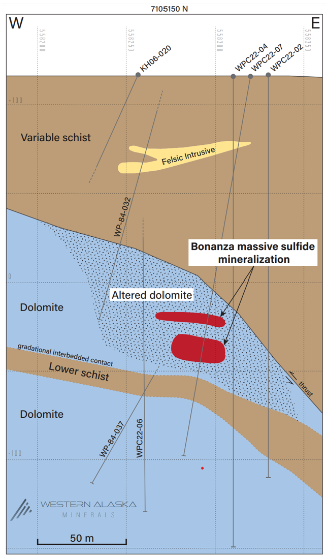
Figure 1. Cross-section (7105150N)
Figure 2 (below) is a longitudinal section along the axis of 2022 Waterpump Creek drilling. The mineralized body plunges to the south at roughly 20 degrees along the western margin of the Waterpump Creek graben. Mineralization thickens dramatically south of 7105050N and could be changing from manto form mineralization to a vertical chimney. Ongoing drilling should further define the geometries of the mineralized body.
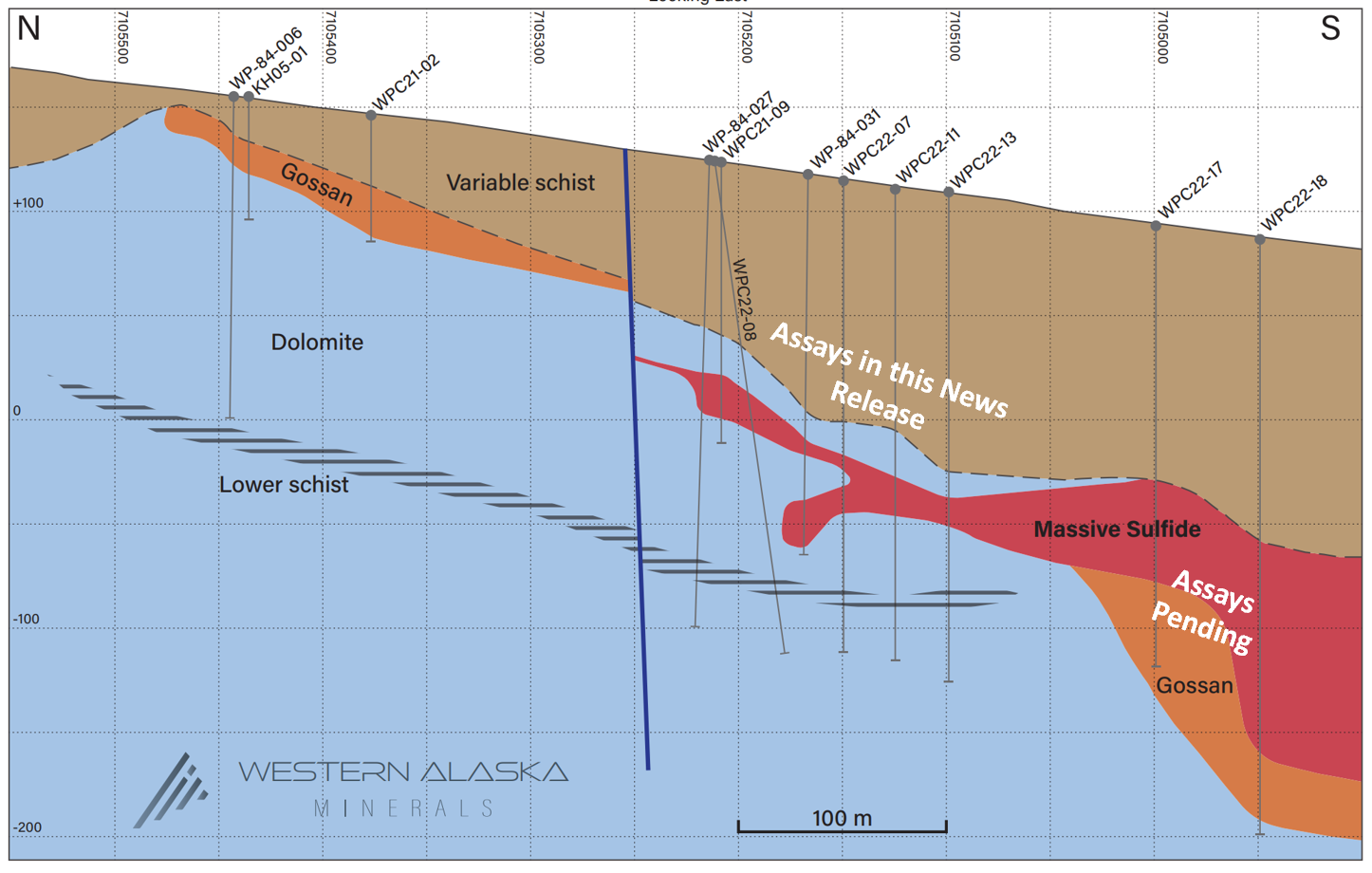
Figure 2. Longitudinal Cross-section down the axis of the Waterpump Creek manto
Figure 3 (below) is a pierce point plan map of 2022 drilling at Waterpump Creek. The plan map shows the limits of the current drilling and thicknesses of the massive sulfide manto as it strikes south from the WPC21-09 discovery hole. Mineralization to the north is offset along a NW trending post mineral fault. WPC22-14 and 15 drilled over and under the horizon respectively as the manto progresses south. Exceptionally thick intercepts in WPC22-17 and 18 are shown and visual results were recently released (See News Release of July 20, 2022). Follow-up drilling along the extensions of the manto from WPC22-18 is ongoing.
Recently drilled WPC22-20 is located 50 meters south and 30 meters east of WPC22-18. WPC22-20 hosts two intervals of massive sulfide mineralization. The mineralization appears similar to that observed in WPC22-18.
Core from WPC22-17, 18 and 20 is currently being processed and assays are pending.
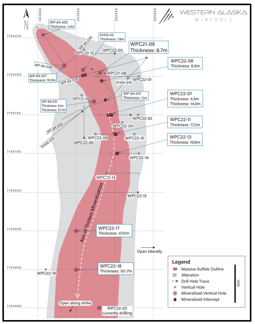
Figure 3. Pierce point Plan Map of the Waterpump Creek manto
CSAMT Geophysical Program
In addition to the ongoing two rig drill program, a major system-wide CSAMT (controlled-source audio-magnetotellurics) program has been completed covering the roughly 8 km distance between the Illinois Creek oxide mineralization, the Last Hurrah area and the Waterpump Creek target area. Inversion modeling of the CSAMT sections is ongoing.
Importantly, preliminary results show a complex interplay of stacked thrusts and high-angle syn-mineral faults. The Waterpump Creek structure, which appears to be the major ore control at Waterpump Creek, is apparent over at least 6 km of strike within the CSAMT sections south from Waterpump Creek through Last Hurrah to just east of the major East IC manto/gossan.
A preliminary geologic re-interpretation is shown in Figure 4 (below) based on the initial CSAMT inversions. A follow-up press release is planned highlighting additional high quality CRD replacement mineralization targets on the property once the final inversions and interpretation is complete.
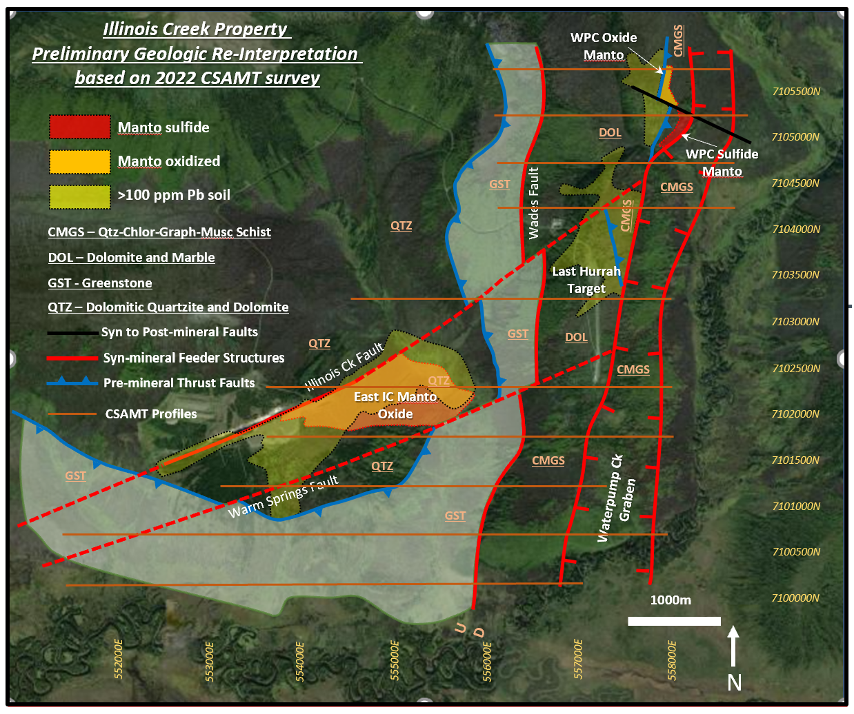
Figure 4. Preliminary Geologic interpretation based on the 2022 CSAMT program
Qualified Person
The qualified person who reviewed and approved the technical disclosure in this release is Stuart Morris, P. Geo., a qualified person as defined under National Instrument 43-101. Mr. Morris is an independent consultant with a MS in Economic Geology and 40 plus years of experience in mineral resources, mine, and exploration He is a Registered Geologist with the British Columbia Association of Professional Engineers and Geoscientists (BC-APEG) No. 135066 and with the Arizona State Board of Technical Registration No. 16289.
His review verified the data disclosed, including geology. sampling, analytical and QA/QC data underlying the technical information in this news release, including reviewing the reports of ALS, methodologies, results, and all procedures undertaken for quality assurance and quality control in a manner consistent with industry practice. All technical matters were consistent and accurate according to his professional judgement.
Quality Assurance/Quality Control
Quality Assurance/Quality Control of drill sample assay results are independently monitored through a quality assurance/quality control ("QA/QC") protocol which includes the insertion of blind standard reference materials, blanks, and duplicates at regular intervals.
All logging and sampling procedures are completed at WAM's core handling facilities located at the Illinois Creek mine camp in Alaska. Drill core is logged under an established procedure using Geospark commercial logging software, then diamond sawn on site. Half drill-core samples are then securely transported to ALS facilities in Fairbanks, Alaska from Illinois Creek under a strict chain of custody protocol. Sample pulps are then sent to ALS's lab in Vancouver, Canada, for analysis. Gold content is determined by fire assay of a 30-gram charge with ICP finish. Silver, lead, copper, and zinc along with other elements are analyzed by ICP methods utilizing a four-acid digestion. Over-limit samples for silver, lead, copper, and zinc are determined by ore-grade titration analyses. ALS Inc. is independent of Western Alaska Minerals and its affiliates.
ALS also performs its own internal QA/QC procedures to assure the accuracy and integrity of results. Parameters for ALS' internal and WAM' external blind quality control samples are acceptable for the elements analyzed. WAM is unaware of any drilling, sampling, recovery, or other factors that could materially affect the accuracy or reliability of the data referred to herein.
About WAM
WAM began trading on the TSX-V in November 2021 and maintains corporate offices in Alaska and Arizona. WAM fully controls all claims in the historic Illinois Creek Mining District located in western Alaska near the Yukon River, covering 55,360 acres (86.5 square miles or 22,403 hectares). This district was originally discovered by Anaconda Minerals Co. in the early 1980's. Since 2010, WAM and its private precursor company Western Alaska Copper & Gold Inc. has reassembled the Anaconda property package and been engaged in exploring the district. The district encompasses at least five deposits containing gold, silver, copper, lead, and zinc.
The Company currently has approximately 19,240,000 common shares issued and outstanding and 238,643 proportional shares issued and outstanding. Each proportional share is convertible to 100 common shares at the request of the shareholder and in the discretion of the Company. Because of these conversion rights, for market capitalization and financial analysis purposes, it is appropriate to convert the proportional shares to common shares and add the product of the conversion to the current number of common shares outstanding. When doing so, the sum of the approximate number of common shares (19,240,000) and converted proportional shares (23,864,300) equals 43,104,300 shares. Further information regarding the Company's share structure is available upon request.
On behalf of WAM
"Kit Marrs"
Kit Marrs
President & CEO
Phone: (520) 200-1667
For further information please contact:
Vanessa Bogaert, Director of Corporate Communications/IR at vanessa@westernalaskaminerals.com
Or visit our website at: www.westernalaskaminerals.com
Forward Looking Information
Certain statements made, and information contained herein may constitute "forward looking information" and "forward looking statements" within the meaning of applicable Canadian and United States securities legislation. These statements and information are based on facts currently available to the Company and there is no assurance that actual results will meet management's expectations. Forward-looking statements and information may be identified by such terms as "anticipates", "believes", "targets", "estimates", "plans", "expects", "may", "will", "could" or "would". Forward-looking statements and information contained herein are based on certain factors and assumptions regarding, among other things, the estimation of mineral resources and reserves, the realization of resource and reserve estimates, metal prices, taxation, the estimation, timing and amount of future exploration and development, capital and operating costs, the availability of financing, the receipt of regulatory approvals, environmental risks, title disputes and other matters. While the Company considers its assumptions to be reasonable as of the date hereof, forward-looking statements and information are not guaranteeing of future performance and readers should not place undue importance on such statements as actual events and results may differ materially from those described herein. The Company does not undertake to update any forward-looking statements or information except as may be required by applicable securities laws.
Neither TSX Venture Exchange nor its Regulation Services Provider (as that term is defined in the policies of the TSX Venture Exchange) accepts responsibility for the adequacy or accuracy of this release.
Appendix 1 - CRD Discussion
A critical element in effective exploration of carbonate replacement (CRD) deposits is a clear understanding of the orebodies' geometries and metal zonation patterns as seen in CRD analogs from around the world. Figure 1 (below) shows plan views of mineralized mantos and chimneys at the Santa Eulalia deposit in Mexico and the Tintic deposit in Utah. Mantos are often characterized as elongate rods of high-grade massive sulfide replacement mineralization in carbonate rocks often 20-100 meters wide, 10-40 metres thick and up to as much 3-4 kilometers in length. These ore body geometries typically result in a 'skeletal hand' distribution of the orebodies exemplified in the figure below.
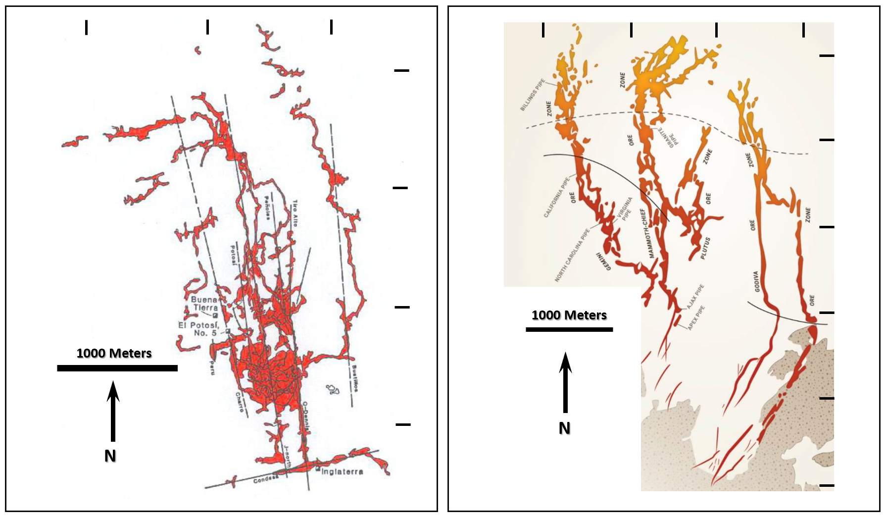
Figure 1. Skeletal Hand Orebody Geometries Santa Eulalia district, Mexico and the Tintic district, Utah (courtesy Peter Megaw)
Figure 2 (below) demonstrates that mineralized mantos can be stacked over a significant vertical relief in any given district. At Santa Eulalia, ore bodies are stacked over a kilometer of vertical stratigraphy. Importantly and as a rule of thumb in CRD exploration, the first favorable limestone or dolomite (i.e., the deepest) encountered by the ascending mineralizer is often by far the most productive. Mantos in general attenuate in scale as you move outward in the system.
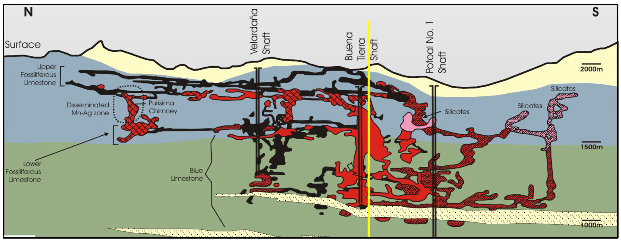
Figure 2. Cross-section of the West Santa Eulalia district showing stacked mantos over 1km of stratigraphic thickness. (courtesy Peter Megaw)
The final critical targeting aspect in CRD exploration is the metal zonation patterns indicative of where in the 'skeletal' geometry the encountered mineralization occurs. Figure 3 (below) shows a plan map of the Hermosa/Taylor deposit in southern Arizona. The deposit exhibits classic CRD metal zonation both laterally and vertically between stacked mantos with proximal Cu-Zn-Ag-Au, intermediate Zn-Pb-Ag and distal Ag-Pb-Zn and Ag-Mn.

Figure 3. Plan view of the Hermosa/Taylor Deposit, AZ showing both lateral and vertical metal zonation in the stacked mantos. (modified from AZ Mining, 2018)
SOURCE: Western Alaska Minerals Corp
View source version on accesswire.com:
https://www.accesswire.com/710451/Western-Alaska-Minerals-Reports-337-GT-108-OzT-Silver-167-Zinc-and-100-Lead-Over-115-Meters-in-WPC22-11-Drilled-Prior-to-the-101-Meter-WPC22-18-Discovery-Hole-at-Waterpump-Creek
