VANCOUVER, British Columbia, April 18, 2024 (GLOBE NEWSWIRE) -- NevGold Corp. ("NevGold" or the "Company") (TSXV:NAU) (OTCQX:NAUFF) (Frankfurt:5E50) is pleased to announce that it has identified significantcopper porphyry potential after completing a geological review and 3-D model of the newly staked Zeus Copper Project in the emerging Hercules Copper Trend in southwestern Idaho. The Company's geological review included detailed assessments of historical records, compilations and reinterpretation of numerous published geological maps, creation of a 3-D geological model, and analysis of rock chip samples collected by the NevGold Team while staking the mineral claims over the past 6 months.
Key Highlights
- Positive results from the geological review and 3-D model highlight the significant copper porphyry potential at the Zeus Copper Project
- Strong similarities have been identified between the Zeus Project and the Hercules Silver Corp. (TSXV:BIG, "Hercules") copper porphyry discovery at the Hercules Project (see Hercules Silver News Release dated October 10, 2023 (https://herculessilver.com/hercules-silver-intersects-185-meters-of-0-84-cu-111-ppm-mo-and-2-6-g-t-ag-including-45-meters-of-1-94-cu-in-first-deep-hole-drilled-at-hercules/)):
- Both projects have Triassic age plutons, the likely source of the copper porphyry
- Both projects have Olds Ferry terrane rocks including the Hercules Rhyolite and Lower Huntington Formation (Seven Devils equivalent)
- Both projects have a cover sequence of Izee terrane rocks including the Weatherby Formation
- Both projects are located along the Bayhorse Thrust Fault, a major structural corridor, which places Izee Terrane rocks (Weatherby Formation) overtop of Olds Ferry terrane rocks (Huntington Formation)
- Both projects have abundant mineral occurrences and historical mine workings
- Both projects are erosional windows through the post-mineral Columbia River basalts that cover the vast majority of the Hercules Copper Trend
- NevGold will rapidly advance preparations for an active field program at Zeus starting in May
NevGold CEO, Brandon Bonifacio, comments: "We are very pleased with how positive the results have been from our upfront geological work on the newly staked Zeus Copper Project. Due to our strong presence in Washington County, Idaho with our Nutmeg Mountain gold project, our team had a robust understanding of the regional geology which we were able to leverage in the identification of the Zeus Project as the next best copper porphyry target on the trend alongside the Hercules Project. Over the past 6 months we have also spent a significant amount of time in the field with our technical team. Instead of utilizing external land staking crews, our core NevGold team completed the staking process which also allowed us to advance surface geology work including reconnaissance mapping and rock chip sampling as we were in the field staking claims. This has been a major advantage in being able to rapidly advance the project. All of the geological signatures that we encountered through our geological review and time in the field solidify our view that Zeus has excellent copper porphyry potential and is some of the most strategic ground in this emerging Hercules Copper Trend."
NevGold VP Exploration, Derick Unger, comments: "The copper potential at Zeus has stood out since our first day in the field when we were finding float samples with copper mineralization and porphyry-style alteration in outcrops. Our enthusiasm for the project has continued to grow as we have completed our geological review. The similarities to the Hercules Project are striking. Both projects host a large suite of rocks from the Olds Ferry terrane including a significant thickness of Hercules Rhyolite which conceals the blind porphyry at the Hercules Project, and will be an important area to test at Zeus. It is also very encouraging that both projects have Triassic age plutons, which is the likely source of the copper porphyry mineralization at the Hercules Project. This suggests there is strong potential for discovery of a blind copper porphyry at Zeus as well. The main focus now is rapidly advancing the project, and we are preparing for an active field program starting in May as the snow melts and the field conditions improve. Zeus offers some of the most compelling copper porphyry targets in this emerging copper trend."
Geology of the Hercules Copper Trend
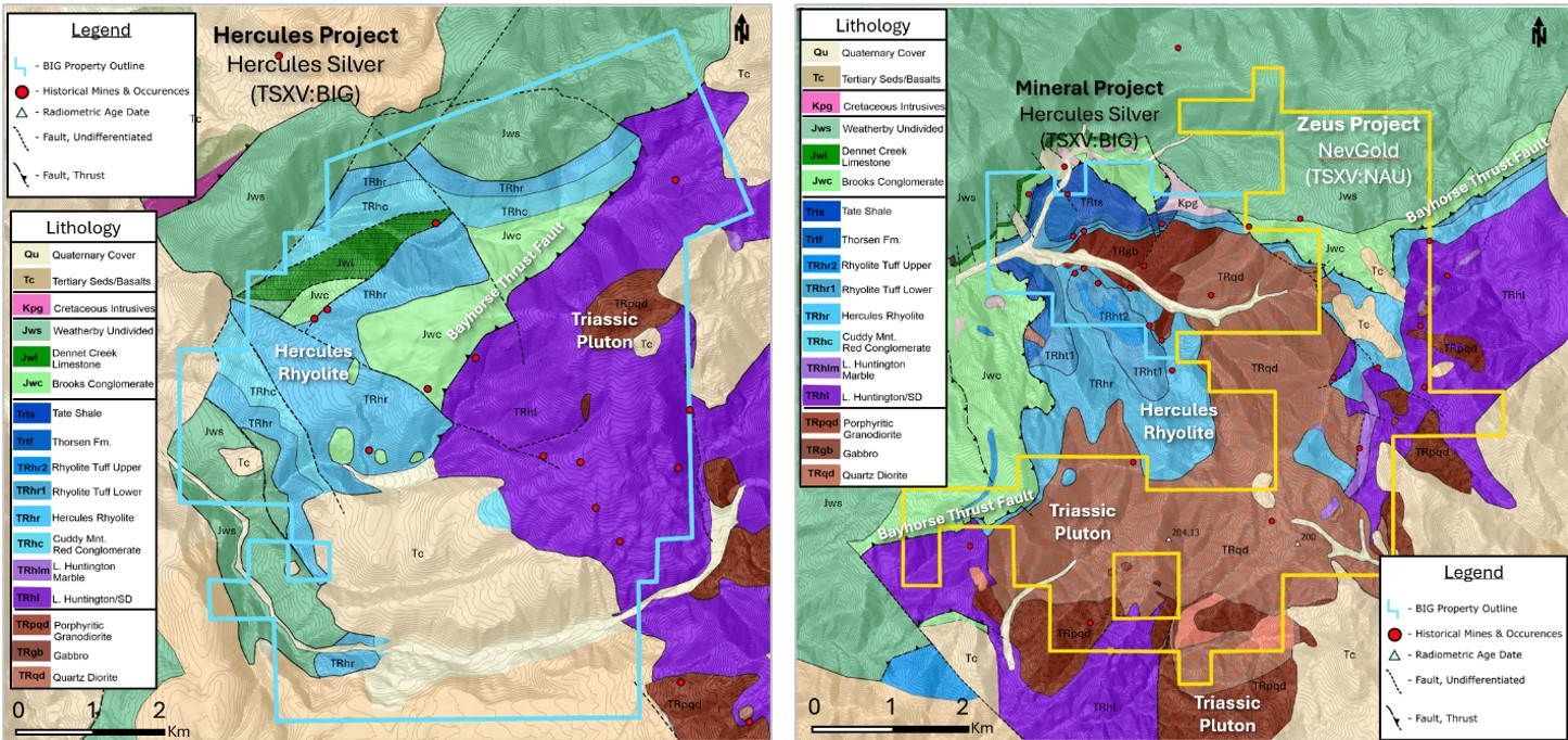
The Hercules Copper Trend is hosted in the Blue Mountain Province, a series of accreted terrains of Permian-Triassic intrusive rocks (plutons) and Triassic-Jurassic volcanic and sedimentary rocks. At the Hercules Project the existence of historically mined silver-base metal veins in the Jurassic volcanic rocks led Hercules to drill beneath the volcanic rocks into the underlying Triassic intrusive rocks where porphyry-style copper mineralization was discovered (Figures 1 and 2). The same geologic conditions identified at the Hercules Project exist at the Zeus Project, where historical production of silver-base metal veins in Jurassic-Triassic volcanic and sedimentary rocks on the western side of the district transitions to Triassic intrusive rocks with porphyry-style alteration and copper mineralization present at surface (Figures 1, 2, 3, and 4).

Figure 1 - Geologic Map of the Hercules Copper Trend compiled by the NevGold geology team.
Modified from (Henricksen, 1974), (Fankhauser, 1968), (Skurla, 1974), (Lund, 2021), (Adair, 1985).
Please click here to view image.
Figure 1 Summary: Figure 1 outlines the geologic map of the Hercules Copper Trend compiled and reinterpreted by the NevGold geology team. As the figure shows, there are many similarities between the Hercules Project and Zeus Project. Both projects exhibit the same host rocks including the Olds Ferry terrane rocks of the Upper Huntington Formation, including the Hercules Rhyolite, as well as rocks of the Lower Huntington Formation (Seven Devils equivalent) which were intruded by Triassic aged plutons and are a likely host to copper porphyry mineralization. Additionally, both projects have significant amounts of Izee terrane rocks of the Weatherby Formation, which are post-mineral and could conceal a copper porphyry deposit.

Figure 2 - Side by Side of Hercules Project and Zeus Project Geology. Maps compiled by NevGold geology team.
Modified from (Henricksen, 1974), (Fankhauser, 1968), (Skurla, 1974), (Lund, 2021), (Adair, 1985).
Please click here to view image.
Figure 2 Summary: Figure 2 outlines that both the Hercules Project and Zeus Project contain the Hercules Rhyolite (light blue) and other Olds Ferry terrane rocks along with Triassic plutons (brown), which have been identified as important factors in the formation and preservation of potential copper porphyry deposits in the district. The similarities between the Hercules Project and Zeus Project are included in the Key Highlights section above.

Figure 3 - Zeus Project Geology Map compiled by NevGold geology team.
Modified from (Henricksen, 1974), (Lund, 2021), (Mitchell & Bennett, 1979).
Please click here to view image.
Figure 3 Summary: Figure 3 identifies the presence of Olds Ferry terrane volcanic and sedimentary rocks of the Huntington Formation (dark to light blue) which host numerous historical mineral occurrences and mine workings that primarily focused on high-grade silver-base metal veins. The Triassic intrusive rocks (brown) lay beneath and intrude into the volcanic and sedimentary rocks and show indications of copper porphyry style mineralization.

Figure 4 - Zeus Project cross-section interpreted by NevGold geology team. Geologic mapping and historical drilling at the Mineral Project (left and center of Figure) suggest a tilted porphyry deposit with the porphyry center east (right side of Figure) of the historical drillholes.
Please click here to view image.
Figure 4 Summary: Figure 4 is a cross-section looking north through the Mineral Project (Hercules) and Zeus Project (NevGold) in the Mineral District. The historical drilling completed at the Mineral Project suggests that there is a tilted copper porphyry deposit with the porphyry center located to the east of the historical drillholes. NevGold's Zeus Project is to the east of the historical drillholes.

Figure 5 - Zeus Project Stratigraphic Column compiled by NevGold geology team.
Modified from (Henricksen, 1974), (Dorsey & LaMaskin, 2007), (Lund, 2021).
Please click here to view image.
Figure 5 Summary: Figure 5 summarizes the stratigraphic units identified in the district. Copper mineralization appears to be related to the Triassic plutons ranging between 210-200 Ma. The United States Geological Survey ("USGS") has dated Triassic plutons on the Zeus Project at 204 Ma and 200 Ma. The silver-base metal mineralization is hosted in the Hercules Rhyolite and other Huntington Formation rocks (Olds Ferry terrain) as well as the Triassic plutons.
Planned 2024 Activities and Status Update
NevGold plans an active exploration program at Zeus in 2024. This program includes:
- Geological review and 3-D model creation (completed);
- Geological mapping (in process);
- Comprehensive surface geochemical sampling (in preparation);
- Geophysics such as magnetics, gravity, EM, CSAMT, or IP (in preparation); and,
- Drill testing copper targets identified by the above activities (subject to the above activities).
History of the Mineral District, Washington County, Idaho
Total historical production from the Mineral District is nearly 1 million ounces of silver, and over 900,000 pounds of copper, along with significant lead and zinc, and minor gold credits (Table 1). Mineralization was first identified in the Mineral District in the 1870's by local prospectors. The early work ultimately led to the development of two smelters where ore was processed and then shipped across the Snake River to Huntington, Oregon (Mitchell V. E., 2000).
The Mineral District has seen minimal modern exploration campaigns. The most notable campaigns were on the land now covered by Hercules' Mineral Project and came from Cyprus Mining between 1968-1970. Cyprus drilled several holes intersecting high-grade silver bearing polymetallic veins and copper mineralization. Two of the holes). To NevGold's knowledge, no modern exploration has been completed at Zeus prior to NevGold staking the project.
The Mineral District has two types of mineralization (Anderson & Wagner, 1952). The majority of the historical ore was produced from silver-bearing veins composed of fine-grained sulphides in calcite gangue. The ore minerals consisted of pyrite, tetrahedrite, chalcopyrite, galena and sphalerite with localized enrichments of marcasite, wurtzite and sulphosalts. The second type of mineralization style in the Mineral District was reported at the Jessie/Condor mine and was characterized by quartz-tourmaline veins that contain tetrahedrite, galena, pyrite, chalcopyrite, and sphalerite, which occurred in fissured and fractured diorite and quartz diorite. In 1901, famous geologist Waldemar Lindgren visited the Mineral District and noted that:
"The Jessie (Condor) represents a totally different type of deposit. Tourmaline veins are, as a rule, connected with deep-seated processes and formed under higher pressure and temperature than ordinary hydrothermal gold and silver veins" (Lindgren, 1901).
Quartz tourmaline veins are often associated with deep seated hydrothermal systems that can serve as indicators of porphyry coppery style deposits due to their association with hydrothermal fluid pathways.
| Mine and Years in Production | Ore (tons) | Old Tailings (tons) | Gold (ounces) | Silver (ounces) | Copper (pounds) | Lead (pounds) | Zinc (pounds) |
| Historical Smelter Production pre-1900* | Unknown | 600,000 | 266,700 | ||||
| Black Hawk Mine (1947) | 21 | 515 | 590 | 247 | |||
| Jessie/Condor Mine (1941) | 12 | 8 | 15 | 705 | |||
| Enterprise Mine (1918-1947) | 210 | 10,306 | 11,560 | 1,928 | |||
| Eagan Mine (1919-1949) | 3,177 | 4 | 4 | 169,051 | 122,524 | 3,205 | |
| Ladd Metals Co. (1903-1905) | 5,673 | 55 | 8,890 | 373,493 | 3,205 | ||
| Other properties (1940) | 26 | 2,630 | 2,022 | 338 | |||
| Silver Still Mine (1922-1950) | 4,989 | 25 | 166,128 | 123,275 | 135,555 | 4,630 | |
| Total for District | 14,108 | 4 | 92 | 957,535 | 900,869 | 144,478 | 4,630 |
Table 1 - Mineral District Historical Production, compiled by Mitchell (2000).

Figure 6 - Zeus Project Location and Hercules Copper Trend
Please click here to view image.
ON BEHALF OF THE BOARD
"Signed"
Brandon Bonifacio, President & CEO
For further information, please contact Brandon Bonifacio at bbonifacio@nev-gold.com, call 604-337-4997, or visit our website at www.nev-gold.com.
Technical information contained in this news release has been reviewed and approved by Derick Unger, CPG, the Company's Vice President, Exploration, who is NevGold's Qualified Person under National Instrument 43-101 and responsible for technical matters of this release.
About the Company
NevGold is an exploration and development company targeting large-scale mineral systems in the proven districts of Nevada and Idaho. NevGold owns a 100% interest in the Limousine Butte and Cedar Wash gold projects in Nevada, and the Nutmeg Mountain gold project and Zeus copper project in Idaho.
Neither the TSX Venture Exchange nor its Regulation Services Provider (as that term is defined in the policies of the TSX Venture Exchange) accepts responsibility for the adequacy or accuracy of this release.
Cautionary Note Regarding Forward Looking Statements
This news release contains forward-looking statements that are based on the Company's current expectations and estimates. Forward-looking statements are frequently characterized by words such as "plan", "expect", "project", "intend", "believe", "anticipate", "estimate", "suggest", "indicate" and other similar words or statements that certain events or conditions "may" or "will" occur. Forward-looking statements include, but are not limited to, the proposed work programs at Zeus, and the exploration potential at Zeus. Such forward-looking statements involve known and unknown risks, uncertainties and other factors that could cause actual events or results to differ materially from estimated or anticipated events or results implied or expressed in such forward-looking statements. Such risks include, but are not limited to, general economic, market and business conditions, and the ability to obtain all necessary regulatory approvals. There is some risk that the forward-looking statements will not prove to be accurate, that the management's assumptions may not be correct or that actual results may differ materially from such forward-looking statements. Accordingly, readers should not place undue reliance on the forward-looking statements. Any forward-looking statement speaks only as of the date on which it is made and, except as may be required by applicable securities laws, the Company disclaims any intent or obligation to update any forward-looking statement, whether as a result of new information, future events or results or otherwise. Forward-looking statements are not guarantees of future performance and accordingly undue reliance should not be put on such statements due to the inherent uncertainty therein.
References
Adair, D. H. (1985). High-Grade Silver Potential of The Hercules Project, Cuddy Mountain District, Idaho. Anglo-Bomarc Mines, LTD.
Anderson, A. L., & Wagner, W. R. (1952). Reconnaissance Geology and Ore Deposits of The Mineral District. . Idaho Department of Land: Bureau of Mines and Geology.
Dorsey, R. J., & LaMaskin , T. A. (2007). STRATIGRAPHIC RECORD OF TRIASSIC-JURASSIC COLLISIONAL. American Journal of Science, Vol. 307 December 2007, P. 1167-1193, DOI 10.2475/10.20007.03.
Fankhauser, R. E. (1968). Geologic Map of The Southern Cuddy Mountains Washington County, Idaho. Idaho Geological Survey.
Henricksen, T. A. (1974). Geology and Mineral Deposits of the Mineral-Iron Mountain District, Washington County, Idaho, And of a Metallized Zone in Western Idaho and Eastern Oregon. A Thesis Submitted to Oregon State University.
Lindgren, W. (1901). The Gold Belt of The Blue Mountains of Oregon. USGS 22nd Annual Report.(1900-1901) pt, 11, pp.561-776.
Lund, K. (2021). Geology of the Payette National Forest and Vicinity, West-Central Idaho. U.S. Department of the Interior, U.S. Geological Survey.
Mitchell, V. E. (2000). History of Selected Mines in the Minerals District, Washington County, Idaho. Idaho Geological Survey, Staff Report 00-14.
Mitchell, V. E., & Bennett, E. H. (1979). Geologic Map of The Baker Quadrangle, Idaho. Idaho Department of Land: Bureau of Mines and Geology.
Skurla, S. J. (1974). Geologic Map of The Sturgill Peak Area, Washington County, Idaho. Thesis Submitted to Oregon State University.


